78% of disasters recorded in the United States each year are weather-related. Still, when asked what type of incidents they expect to respond to over the next year, Emergency Management Personnel (EMP) and public safety officials underestimate the number of weather-related disasters that will occur. This misconception results in EMP and public safety officials being undertrained to respond to weather-related disasters. In order to more effectively and cost efficiently keep the public safe, EMP and public safety officials need to be more knowledgeable about weather phenomenon and the impact severe weather can have on their communities. In the United States, there are a few weather threats that are nearly universally experienced across the country. These are thunderstorms, tornadoes, lightning, and hailstorms.
Thunderstorms
The most common severe weather threats seen in the United States and worldwide are thunderstorms. A thunderstorm is a rain shower which features thunder. Since thunder is generated from lightning, all thunderstorms feature lightning, whether frequently visible or not. There are approximately 100,000 thunderstorms each year in the U.S. alone. While this indicates that thunderstorms are quite common, specific atmospheric conditions must be present for a thunderstorm to form. Three basic ingredients are required for the formation of a thunderstorm:
- Moisture: This needed to form clouds and rain.
- Unstable Air: Air that is relatively warm and can rise rapidly.
- Lift: from fronts, sea breezes or mountains
Lightning is produced high in thunder clouds when liquid and ice particles above the freezing level collide and build up large electrical fields. Once these electric fields become large enough, a giant “spark” occurs between them (or between the particles and the ground) like static electricity, reducing the charge separation. The lightning spark can occur between clouds, between the cloud and air, or between the cloud and ground. Thunder is caused by the rapid expansion of the air surrounding the path of a lightning bolt.
It is likely that nearly all Americans have experienced a storm in their lives that featured the above characteristics. However, the majority of thunderstorms, while impressive to watch, are mostly harmless. Only about 10% of thunderstorms reach severe levels. A thunderstorm is classified as severe when it contains one or more of the following:
- Hail one inch or greater
- Winds gusting in excess of 50 knots (57.5 mph)
- A tornado
These criteria are not widely known by laypeople, so, in an effort to better communicate severe weather hazards and risk, the National Weather Service (NWS) Storm Prediction Center released a graphical table which concisely describes the hazards associated with five increasing levels of severe weather risk intended to complement the maps they release every day.
|
Thunderstorms |
Marginal |
Slight |
Enhanced |
Moderate |
High |
|
No severe storms expected. |
Isolated severe thunderstorms possible |
Scattered severe storms possible |
Numerous severe storms possible |
Widespread severe storms likely |
Widespread severe storms expected |
|
Lightning/flooding threats exist with all thunderstorms |
Limited in duration and/or coverage and/or density |
Short and/or non-expansive, isolated intense storms possible |
More persistent and/or widespread, a few intense |
Long-lived, widespread, and intense |
Long-lived, widespread, and particularly intense |
|
Features: winds up to 40 mph, small hail |
Winds 40-60 mph, hail up to 1”, low tornado risk
|
One or two tornadoes, several reports of wind damage, hail 1-2” |
Same as slight, but a few tornadoes |
Strong tornadoes, widespread wind damage, hail 2+” |
Tornado outbreak, derecho |
Tornadoes
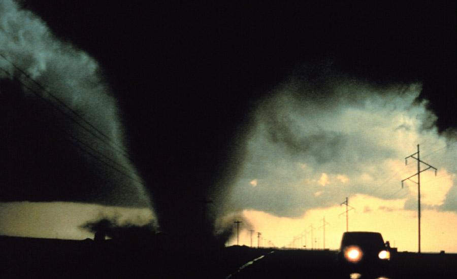
One of the characteristics of a thunderstorm that will make the NWS classify it as severe is the presence of one or more tornadoes. Tornadoes, though, are much more than a characteristic of a severe thunderstorm. They are a severe weather threat all their own – perhaps the most dangerous of the common threats discussed in this article. And they are quite common -- The US leads the world with an average of 1,000 tornadoes every year. Tornadoes are the most violent of all atmospheric storms. A tornado is a swiftly rotating column of air that descends from the bottom of a thunderstorm cloud to the ground. Tornadoes become visible as a condensation funnel is created. The funnel is composed of water droplets and dust and debris swept up from the ground. The most destructive and deadly tornadoes are born of supercells – giant rotating thunderstorms with a defined radar circulation called a mesocyclone. While much research has been conducted around tornadoes, researchers are still not entirely sure what exact combination of circumstances are needed for their creation. The most common theories revolve around the temperatures and downdrafts in and around the mesocyclone.
While tornadoes can occur any time of year, peak season for the hardest hit regions of the country are:
- Southern Plains: May into early June
- Southeastern US: Early spring and fall
- Gulf coast: Early spring
- Northern plains/upper Midwest: June or July.
Most tornadoes occur between 4 and 9 p.m., but can happen at any time of day when conditions are favorable.
The NWS uses a watch and warning system to indicate the tornado threat level in an area during a severe thunderstorm. A Tornado Watch is issued by NOAA Storm Prediction Center meteorologists when conditions are favorable for a tornado. A watch can cover parts of a state or several states. The NWS recommends residents in the area of a Tornado Watch review and discuss their emergency plans, and be ready to act quickly if a warning is issued or if a they suspect a tornado is approaching. A Tornado Warning is issued by the local National Weather Service Forecast Office responsible for monitoring weather in a specific region. A Tornado Warning means a tornado has been reported by spotters or identified by radar. This designation signifies that persons and property in the path of the tornado are in serious danger. Residents should take shelter at once. Warnings can apply to parts of counties or multiple counties along the anticipated tornado track and typically last less than an hour.
Lightning
A few key facts about lightning:Another characteristic of severe thunderstorms that is a real threat even considered on its own is lightning. Cloud-to-ground lightning bolts are a common phenomenon – about 100 strike Earth’s surface every single second – and yet their power is extraordinary. Each bolt can contain up to one billion volts of electricity and travels at 90,000 miles/second. A bolt can be over five miles long and can strike up to 10 miles from an area of rainfall. In the United States, there are about 25 million lightning flashes every year. While lightning fatalities have decreased over the past 30 years, lightning continues to be one of the top weather killers in the United States: lightning causes an average of 50- 60 fatalities each year. Research has shown that dramatic increases in lightning over a short period of time, especially positive strikes, indicates storm intensification.
A few key facts about lightning:
- Standing under a tree is the second leading cause of lightning fatalities. If you must be outside during a thunderstorm, under a tree is not a safe place to take shelter.
- Rubber-soled shoes do not provide any meaningful protection from lightning.
- Victims of lightning do not retain the charge and are not electrified. It is safe to help them.
Hail is another aspect of a thunderstorm that when present in certain forms, with cause the NWS to classify the storm as severe. Again, like lightning, hail is also a threat considered on its own, but is even more threatening when present in the typical conditions of a storm. Hail forms when the warm updraft of a thunderstorm pushes water droplets high enough into the clouds to freeze. These frozen droplets are caught by the storm’s cold downdraft and pushed down into warmer air. As the frozen droplets begin to melt, they pick up more water droplets and grow larger. With each pass of this cycle, the frozen water droplets become bigger and heavier. Eventually, the updrafts are no longer strong enough to push the large droplets up and around, so the balls of ice finally fall to the ground as hail. The stronger the updraft, the larger the hailstones become.
According to the National Weather Service, hail is generally no larger than 2-inches in diameter. However, hail has been known to come in many different shapes and proportions and a standard scale was developed to describe it, ranging from nickel-sized (roughly .75” in diameter) to softball-sized (4.5 inches in diameter). Hail as small as 1” in diameter can cause damage, and severe thunderstorms can feature hail 2” and larger.
A tool to track tornadoes, other severe weather threats
Throughout this article, we have discussed the various kinds of common severe weather threats in the United States. But how can EMP and public officials know for sure when a weather event has reached severe levels? An example of a tool that public safety officials and EMP can use to help them protect their area with precision is Baron Threat Net. Baron Threat Net is a web-based meteorological tool that provides critical weather intelligence when and where it is needed most. Baron Threat Net delivers the features safety officials need to be decisive and accurate when responding to severe weather. With a tool like Threat Net, EMP can easily track tornadoes, flooding, lightning strikes, dangerous road conditions, hail coverage and probability and more. No matter the location, severe weather can strike in many forms. One thing is certain: mother nature won’t wait. It is up to EMP and public officials to educate themselves on the threats posed to their region, to use the appropriate tools to track those threats, and then to act on those threats appropriately.


